Travel and Dream

  • Home
  • Africa
  • _The Gambia
  • _Morocco
  • Europe
  • _Germany
  • _Hungary
  • _Latvia
  • _Spain
  • _United Kingdom
  • Middle East
  • _Oman
  • _UAE
  • USA
  • _California
  • _Utah
  • Contact


There are numerous hikes you can take in Yosemite National Park. We were there only for a couple of days during our great road trip through west USA. For this reason we chose to do the iconic Mist Trail, Yosemite’s signature hike. It will lead you to not just one, but two magnificent waterfalls with fabulous views scattered all along the trip.

The trailhead is located at Happy Isles (shuttle stop 16).  To get there you can park your car in Curry Village and take the free shuttle. However, we decided to walk the 1.6 kilometers to the start of the trail.

Mist Trail part I: Vernal Fall

The first part of the trail is a well-paved path alongside the beautiful Merced River, but it is a bit crowded with people wanting to get a glimpse of the first majestic waterfall, the Vernal Fall. After one kilometer we reach the footbridge over the Mercer River with a spectacular view of the Vernal Fall. A drinking fountain and restrooms are also located here.

The first glimpse of the astonishing falls


We continue the trail for another kilometer until we hit the impressive granite stairway carved into the canyon wall leading to the top of Vernal Fall. This is the most exciting part of the trail! Here we also discover how the Mist Trail got its name. The spray from the waterfall will get you soaking wet, whilst going up the hundreds of granite steps. A nice refreshment during this strenuous uphill climb.

This part of the trail can get very crowded, and the obvious lack of preparedness of some people can be a bit frustrating. You will see people on flip-flops going down the slippery wet steps, holding on to anything they can find because the fear (of heights) got the better of them. Our advice: Come prepared, and do not underestimate this part of the hike.

Lots of traffic on the beautiful granite stairway

The stairs are pretty steep too..

... but the view is A-MA-ZING!


After we reach the top of the Vernal Fall we take a moment to catch our breath and enjoy the amazing view looking down the waterfall.

Mist Trail part II: Nevada Fall

From this point, you have 3 options on how to proceed your hike. You can head back the way you came, or you can return to the trailhead by taking a longer route via the John Muir Trail. But, if you’re up for it, you can also continue the Mist Trail to the top of the amazing Nevada Fall, with the extra bonus that the trail will be far less crowded from this point on. We chose the last option of course!

Standing on the edge (don't worry, there's a railing)


The next kilometer leads us through a beautiful pine forest along the Merced River. Here you have a perfect view of the Nevada Fall. We keep walking through the forest until we run into a set of steep and rocky switchbacks that will take us up to the top of the 180 meters long Nevada Fall. The view that you get from these switchbacks is absolutely magnificent and is well worth the climb. At the top of the fall, we take again some time to rest and enjoy the beautiful view over the Yosemite Valley.


Nevada Fall. Wow!

Keep your food close. The wildlife at the top are sneaky little thieves

Now it’s time for the trip back. Again you can return back down the way you came which is about 4 kilometers. But we choose to go via the John Muir Trail, which is a bit longer, about 6.5 kilometers. A good choice, because it offers a stunning view of Nevada Fall with the Liberty Cap and the back of the Half Dome in the background. The remainder of this trail is a peaceful and easy descent through a shady forest back to the footbridge where the trail started.

What a view!

Facts:

Distance: The Mist Trail to the top of the Vernal Fall is 2.8 kilometers, and back via the John Muir Trail is around 6 kilometers. The Mist Trail to the top of the Nevada Fall is 5.3 kilometers, and back via the John Muir Trail is around 12 kilometers.
Elevation change: The elevation at the trailhead is 1.2 kilometers. The top of the Vernal Fall is at an elevation of 1.5 kilometers. The top of the Nevada Fall is 1.8 kilometers. So for the full trip a total elevation change of 600 meters.
Difficulty: National Park Services rates the trail as strenuous
Trailhead: Happy Isles shuttle stop
Weather: The water level in the Merced River is depending on the seasons. For the highest flow and most powerful waterfalls, we recommend hiking this trail in the spring or early in the summer, when the winter snow is melting. In the winter the Mist Trail is closed because of icy conditions.

Tips:

  • Bring plenty of water, especially in the summer it can get very hot.
  • Wear appropriate hiking shoes with lots of traction; no sneakers, Converse or flip-flops!
  • Start this hike early in the day to avoid the crowds and the midday heat
  • Do not swim or wade in the river. The river looks much less dangerous than it actually is. In fact, the current can be too strong to overcome, and it can sweep you right over the waterfall.
  • For more information about the route, click here.

Have you hiked to the Vernal Fall and Nevada Fall? If so, let me know in the comments below!

Like it? Pin it!


  • 0 Comments

Zion’s Angels Landing Trail is one of the most famous and thrilling hikes for adventure seekers. During our road trip through west-USA, we visit Zion National Park, just so that we could cross the Angels Landing off our bucket list. Hiking this trail quickly became a highlight of our road trip.

The trailhead is across the road from the Grotto Picnic Area. We take the free shuttle from the visitor center to get here. From the Grotto shuttle stop, we cross the river and road to get to the trailhead. Here you get a clear view of the Angels Landing and where we will be standing in a few hours.

Let's go to the top

Let’s start

The first kilometer is a steady uphill climb over a wide trail. After a while, we hit the steep switchbacks that take us up to Refrigerator Canyon. As the name suggests, this narrow and shady canyon is always cool with a comfortable breeze. A pleasant place to cool off and catch your breath after the hot and sweaty first climb.

The first set of switchbacks


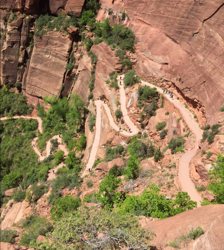
Next up, we encounter the second steep climb of this trail, Walter’s Wiggles, a series of 21 tight switchbacks carved into the face of the cliff. After this, we quickly rise to the top of the ridge at Scout Lookout. From here we get a pretty good preview of the last kilometer of the hike along the ridge. This is where you can decide if you want to pursue the last ridiculously steep but most thrilling part of the hike or that you want to turn around and head back down.


Walter's Wiggles from the top

From this point on it will get really interesting!

But be careful! Six people have died already on this trail


Don’t look down

On the ridge, we experience ourselves why this trail is not for the faint-hearted. The path gets smaller and smaller, eventually to only a few feet wide, with drop-offs on either side. Eventually, we find ourselves holding on to the chains more often. On certain points you really don’t want to let go of the chains, when you’re stepping from one sandstone boulder to the next, dangling 300 meters above the ground. If you dare to look down, you’ll see the valley and the river getting smaller and smaller. This is the most exciting part of the trail and will definitely give you an adrenaline rush.

Don't look down!

At the top of the ridge, we are treated to the most magnificent view over the Zion Canyon. Together with some crazy chipmunks and lots of fellow hikers, we enjoy the view for a while before we make our descent.

Incredible view from the top of Angels Landing

Facts:

Distance: 8 km (round trip)
Elevation change: 450 m
Difficulty: Strenuous, steep with exposure to long drop-offs
Trailhead: The Grotto shuttle stop
Weather: The best time of the year to hike Angels Landing is in spring, summer, and fall.

Tips:

  • Bring plenty of water. Especially in the summer, when it can get very hot and the shade will be hard to find.
  • Use a backpack, make sure your hands are free to hold the chains.
  • Wear appropriate hiking shoes; no sneakers, Converse or flip-flops!
  • Do not underestimate this hike! This trail is not suitable for inexperienced hikers, people who have a fear of heights, or young children.
  • The trail can get very crowded. Many sections are only wide enough for one-way traffic. You’ll have to stop several times to let people pass. We recommend starting your hike early in the morning to avoid the crowd.
  • For more information about the route, click here.

Have you hiked to the Angels Landing?

Like it? Pin it!


  • 0 Comments


The United States is probably the best place in the world for road tripping. I mean, the country is basically built for cars. As a planning and organizing geek, I love to plan out road trips and research the web to make sure we absolutely don’t miss anything while we’re on the road.

Are you looking for west USA road trip itinerary inspiration, this is the place to start. In this post, I share our itinerary for the 16-day road trip through the west of the USA, that we made in May 2016. We mixed comfortable hotels with adventurous outdoor campsites. This 4200-kilometer route starts and ends in Los Angeles, covering three major cities, four states, and five National Parks!


Day 1 | Arrival in Los Angeles

Hotel: Value Inn Worldwide LAX, Los Angeles, CA
Description: Our plane landed pretty late in the evening in LA, so we chose a hotel close to the airport. Not the fanciest location, but it’s convenient, cheap, and only for one night of sleep anyway.
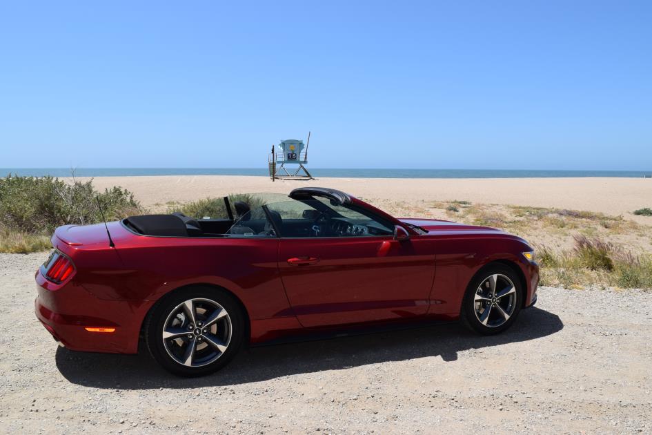
Tips: Rent an All-American Muscle car. Compared to European prices, it is very affordable in the US. We rented a Ford Mustang convertible and fell in love with it right away.


Day 2 | Los Angeles – San Simeon

Hotel: San Simeon Lodge, San Simeon, CA
Distance: 400 km
Description: Today the road trip really starts. Take the famous Pacific Coast Highway to Malibu and make several stops on the coastline to enjoy the sun and the sea. There are plenty of beautiful white beaches with iconic blue lifeguard towers along the way.
Tips: Stop for a lunch in the beautiful town of Santa Barbara | Watch the sunset over the ocean

Day 3 | San Simeon – San Francisco

Hotel: La Luna Inn, San Francisco, CA
Distance: 350 km
Description: One of the most spectacular drives in the world, the Big Sur, is scheduled for today. Take your time and make sure to stop multiple times to enjoy the stunning scenery.
Tips: See the Elephant Seals at Piedras Blancas | Have a short break at McWay Falls and Pfeiffer Beach | Drive the 17-mile drive in Monterey | Visit the Santa Cruz Boardwalk


Day 4 | San Francisco

Hotel: La Luna Inn, San Francisco, CA
Description: A full day to explore The City by the Bay, San Francisco
Tips: Forget the car: purchase a 1-day pass for the public transport and take the trolleybus, this pass also includes a ride with the historic Cable Cars | Enjoy the views at Pier 39 | Make a trip to Alcatraz | Visit the Painted Ladies, the iconic colored houses

Day 5 | San Francisco – Yosemite National Park

Campsite: Lower Pines Campground, Yosemite Valley, CA
Distance: 350 km
Description: First, make sure to head North to drive over the Golden Gate bridge (this is the toll-free direction), and make a quick stop to take a picture of the bridge with the city in the background. Then head to the east towards Yosemite National Park. At the entrance, you can buy the Annual National Park pass, that provides access to all National Parks during this trip.
Note: The campsites in Yosemite are very popular so make a reservation in advance. The reservation system opens 5 months in advance, see the official website for more information. When we booked, the campsites were sold-out within a day.

Day 6 | Yosemite National Park

Campsite: Lower Pines Campground, Yosemite Valley, CA
Description: A full day to explore Yosemite. Go hiking, the wide array of trails in the park vary in difficulty levels as well as scenic views. Our favorite is the Mist Trail, one of Yosemite’s signature hikes.

Read more: Hiking the Mist Trail in Yosemite


Day 7 | Yosemite National Park – Las Vegas

Hotel: Flamingo, Las Vegas, NV
Distance: 780 km
Description: Prepare for a long day in the car. Because Highway 120 was closed when we were there, so we chose to go via Fresno and Bakersfield. We left Yosemite around 7.30am, had lunch along the way, and arrived in Las Vegas around 4.00pm. Alternatively, you can take Highway 120 and go through Death Valley National Park, which is a bit longer.

Day 8 | Las Vegas

Hotel: Flamingo, Las Vegas, NV
Description: Sin City is yours to explore today.
Tips: Gamble in the casinos. Spend your time people-watching on the Strip. Go to one of the shows. Explore the over-the-top hotels such as The Bellagio, Caesars Palace, The Venetian or Paris.

Day 9 | Las Vegas – Zion National Park

Campsite: Watchman Campground, Springdale, UT
Distance: 250 km
Description: The camping journey continues. Again, you’ll spend the night in a tent underneath the stars, right in the middle of a National Park.
Tips: Leave Las Vegas early in the morning, this way you’ll have plenty of time in the afternoon to walk one of the many amazing hikes in Zion. The Angels Landing Trail is our favorite.

Read more: Hiking the Angels Landing Trail in Zion National Park


Day 10 | Zion National Park – Bryce Canyon National Park

Campsite: Sunset Campground, Bryce Canyon NP, UT
Distance: 130 km
Description: Explore the iconic hoodoos in Bryce Canyon National Park.
Tips: Bryce Canyon can be very cold at night, even in the early summer. Take this into account if you choose a campground or a hotel.

Day 11 | Bryce Canyon National Park – Monument Valley

Campsite: Goulding’s Campground, Oljato-Monument Valley, UT
Distance: 450 km
Description: Leave Bryce Canyon in the morning and prepare for some stops along the way.
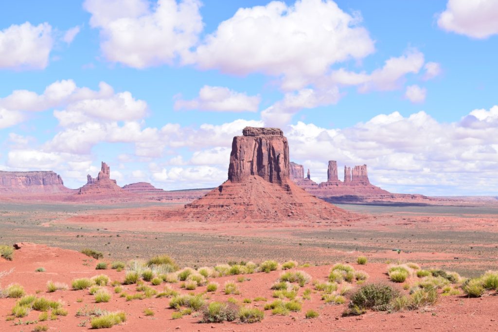
Tips: Make sure to stop at the Horseshoe Bend just outside of Page | Join a tour to the photogenic Antelope Canyon | Drive a little further then the campground to visit the iconic Forest Gump photo spot in Monument Valley (You know, the one where he stops running) | Drive the 17-mile off-road drive through the park.  


Day 12 | Monument Valley – Grand Canyon National Park

Campsite: Mather Campground, Grand Canyon Village, AZ
Distance: 290 km
Description: Today you’ll drive to another highlight of this trip, the world-famous and breathtaking Grand Canyon
Tips: Visit the Visitor Center and watch a short movie about the origin of the Grand Canyon | Go to one of the many viewpoints around the National Park and enjoy the nature | Take a hike | Grand Canyon NP is at a high altitude and it can get could in the evening

Day 13 | Grand Canyon National Park – Lake Havasu City

Hotel:  Travelodge Lake Havasu, Lake Havasu City, AZ
Distance: 370 km
Description: From the cold to the hot. Lake Havasu City is located in the middle of the desert on Lake Havasu (what’s in the name)
Tips: Make sure to visit Seligman along the way and explore the historic route 66 vibes | Enjoy the nice warm sunny weather | Dive into the beautiful blue lake


Day 14 | Lake Havasu City – Palm Springs

Hotel: Holiday Inn Express, Palm Desert, CA
Distance: 300 km
Tips: Visit Joshua Tree National Park along the way | Go shopping in Palm Desert

Day 15 | Palm Springs – Los Angeles

Hotel: Hollywood Historic Hotel, Los Angeles, CA
Distance: 225 km
Description: Things have come full circle. Today you are back in LA again.

Day 16 | Los Angeles

Hotel: Hollywood Historic Hotel, Los Angeles, CA
Tips: Visit the ever vibrant Venice Beach | Stroll on the Santa Monica pier | Go see the stars on Hollywood Boulevard | See where the celebrities live and shop in the Hills and Rodeo Drive | Visit a baseball match


Facts & Figures

Number of days: 16
Major Cities: 3
States: 4
National Parks: 5
Distance: 4000 km
Gas expenses: € 210
Average price per night: € 70


Click here for an overview of the road trip including hotels and campsites on Roadtrippers.com (tip! very handy website to plan you’re road trip. It will show you all the interesting places along your route)


Are you going to do a road trip in the US? Or did you go already and do you have new tips? I would love to hear from you in a comment below.

Like it? Pin it!


  • 0 Comments
Older Posts Home

Where we are now

o

About me

a


Paulien

"The most important thing is to enjoy your life — to be happy — it’s all that matters.”


Follow Me

  • bloglovin
  • pinterest
  • instagram
  • facebook
  • Twitter
  • YouTube

Banner spot

recent posts

Contact Form

Name

Email *

Message *

About Me

Paulien
View my complete profile

instagram

Template Created By :Blogger Templates | ThemeXpose . All Rights Reserved.

Back to top